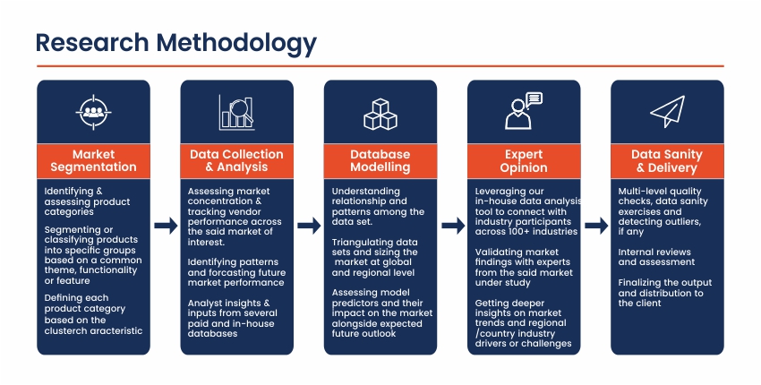
Market Overview
The North America remote sensing services market plays a crucial role in a wide range of applications, including environmental monitoring, natural resource management, urban planning, agriculture, and defense and security. Remote sensing involves the acquisition and analysis of data about the Earth’s surface and atmosphere using sensors mounted on satellites, aircraft, or other aerial platforms. These services provide valuable insights and information by capturing and interpreting data from remote or inaccessible areas, enabling informed decision-making and effective resource management.
The North America region, comprising the United States and Canada, is a significant contributor to the global remote sensing services market. This region is home to several leading companies, research institutions, and government agencies that drive the development and adoption of remote sensing technologies. The strong emphasis on technological innovation, coupled with the increasing demand for accurate and timely data across various sectors, has fueled the growth of the remote sensing services market in North America.
Key Takeaways of the Market
- The North America remote sensing services market is expected to experience substantial growth, driven by the increasing demand for geospatial data and the need for efficient monitoring and management of natural resources.
- The market is witnessing a surge in demand for high-resolution satellite imagery and advanced data analytics capabilities to support decision-making processes across various industries.
- The integration of emerging technologies, such as artificial intelligence (AI), machine learning (ML), and cloud computing, is enhancing the capabilities of remote sensing services, enabling more accurate and efficient data analysis.
- The market is highly competitive, with various players offering specialized services tailored to specific applications and industries.
- The need for sustainable resource management and environmental monitoring is driving the adoption of remote sensing services in sectors such as agriculture, forestry, and environmental conservation.
- Government initiatives and funding programs are supporting the development and utilization of remote sensing technologies for applications in national security, defense, and disaster management.
Market Driver
One of the primary drivers of the North America remote sensing services market is the increasing demand for accurate and timely geospatial data across various industries. Remote sensing services provide valuable insights into land cover, vegetation patterns, urbanization trends, and environmental changes, enabling informed decision-making and effective resource management. The ability to monitor and analyze large geographical areas from a distance has made remote sensing an indispensable tool for industries such as agriculture, forestry, mining, and urban planning.
Additionally, the growing emphasis on environmental sustainability and the need for efficient natural resource management have fueled the demand for remote sensing services. These services play a crucial role in monitoring deforestation, land degradation, water resources, and biodiversity, enabling proactive conservation efforts and informed policy decisions. The ability to track environmental changes over time and identify potential threats has made remote sensing a valuable asset in addressing environmental challenges.
Market Restraint
One of the major restraints in the North America remote sensing services market is the high cost associated with acquiring and operating advanced remote sensing technologies. These services often require significant investments in satellites, aircraft, sensors, and data processing infrastructure. The cost of launching and maintaining satellites, as well as the specialized expertise required for data analysis and interpretation, can be prohibitive for smaller organizations or businesses with limited budgets.
Furthermore, the complex regulatory landscape surrounding remote sensing activities, particularly in the defense and national security sectors, can pose challenges for market growth. Strict regulations governing data acquisition, data sharing, and export controls may limit the ability of service providers to expand their operations or collaborate with international partners, hindering market expansion and innovation.
Market Opportunity
The integration of emerging technologies, such as artificial intelligence (AI), machine learning (ML), and cloud computing, presents a significant opportunity for the North America remote sensing services market. These technologies can enhance the capabilities of remote sensing services by enabling more accurate and efficient data analysis, faster processing times, and improved data accessibility.
AI and ML algorithms can be applied to remote sensing data to identify patterns, detect anomalies, and extract valuable insights, enabling more informed decision-making across various industries. Cloud computing platforms can facilitate the storage, processing, and dissemination of large volumes of remote sensing data, making these services more accessible and scalable for a wider range of users.
Market Segment Analysis
- Environmental Monitoring and Natural Resource Management Segment The environmental monitoring and natural resource management segment is a significant contributor to the North America remote sensing services market. Remote sensing technologies play a crucial role in monitoring environmental conditions, tracking land use changes, assessing biodiversity, and managing natural resources such as forests, water bodies, and mineral deposits.
Within this segment, remote sensing services are utilized for applications such as deforestation monitoring, wildlife habitat mapping, water resource management, and land degradation assessment. These services provide valuable data and insights for environmental agencies, conservation organizations, and resource management authorities to make informed decisions and implement effective strategies for sustainable resource utilization and environmental protection.
- Defense and Security Segment The defense and security segment is another prominent driver of the North America remote sensing services market. Remote sensing technologies are essential for various defense and security applications, including intelligence gathering, border surveillance, target identification, and terrain mapping.
Within this segment, remote sensing services are utilized for applications such as reconnaissance, strategic planning, and situational awareness. These services provide critical information for military operations, homeland security, and disaster response efforts. Advanced sensor technologies, high-resolution imagery, and real-time data analysis capabilities are crucial for ensuring national security and enabling rapid response to potential threats.
Regional Analysis
The United States dominates the North America remote sensing services market, driven by its significant investments in space technology, defense capabilities, and environmental monitoring initiatives. The country’s well-established aerospace and defense industries have played a pivotal role in driving the development and adoption of advanced remote sensing technologies.
Furthermore, the presence of numerous government agencies and research institutions, such as NASA, NOAA, and the U.S. Geological Survey (USGS), has contributed to the growth of the remote sensing services market in the United States. These organizations have made substantial investments in satellite missions, data acquisition, and analysis capabilities, fostering innovation and driving the adoption of remote sensing services across various sectors.
Canada is also a significant contributor to the North America remote sensing services market. The country’s vast natural resources and emphasis on environmental protection have driven the demand for remote sensing services in areas such as forestry, agriculture, and resource management. Additionally, Canada’s participation in international space programs and its collaborations with the United States have further contributed to the growth of the remote sensing services market within the region.
Competitive Analysis
The North America remote sensing services market is highly competitive, with various players offering specialized services tailored to specific applications and industries. Major players in this market include DigitalGlobe (a subsidiary of Maxar Technologies), Planet Labs, Airbus Defence and Space, Harris Corporation, and e-GEOS (a subsidiary of Telespazio).
DigitalGlobe (Maxar Technologies) is a leading provider of high-resolution satellite imagery and geospatial services. The company operates a constellation of advanced Earth observation satellites and offers a wide range of services, including imagery analysis, data fusion, and geospatial intelligence solutions.
Planet Labs is a pioneering company in the field of nano-satellite constellations, providing high-frequency and high-resolution imagery of the Earth’s surface. The company’s innovative approach to satellite technology has enabled it to offer unique services, such as daily monitoring of global changes and real-time insights.
Airbus Defence and Space is a major player in the remote sensing services market, offering a range of solutions for defense, security, and commercial applications. The company operates a fleet of Earth observation satellites and provides services such as imagery analysis, mapping, and geospatial intelligence.
Harris Corporation is a renowned provider of advanced remote sensing solutions for defense, intelligence, and environmental monitoring applications. The company offers a wide range of services, including data acquisition, processing, and analysis, as well as specialized software and systems for remote sensing operations.
e-GEOS (Telespazio) is a leading provider of geospatial services and solutions, specializing in Earth observation and monitoring. The company offers a range of services, including satellite imagery analysis, mapping, and environmental monitoring, catering to various industries and government agencies.
Key Industry Developments
- The deployment of advanced satellite constellations and the increasing availability of high-resolution imagery, enabling more detailed and frequent monitoring capabilities.
- The integration of artificial intelligence (AI) and machine learning (ML) algorithms for automated image analysis, pattern recognition, and data extraction from remote sensing data.
- The adoption of cloud computing platforms for efficient storage, processing, and dissemination of large volumes of remote sensing data.
- The development of hyperspectral and multispectral sensors, providing more detailed information about the Earth’s surface and enabling advanced applications in areas such as mineral exploration and environmental monitoring.
- The increasing use of unmanned aerial vehicles (UAVs) and drones for remote sensing applications, offering more flexibility and cost-effective data acquisition capabilities.
- The emergence of public-private partnerships and collaborative efforts between government agencies, research institutions, and commercial entities to advance remote sensing technologies and services.
- The growing emphasis on data fusion and integrating remote sensing data with other sources of information, such as ground-based measurements and social media data, for more comprehensive analysis and decision-making.
Future Outlook
The future outlook for the North America remote sensing services market remains promising, driven by the increasing demand for accurate and timely geospatial data, the need for efficient natural resource management, and the ongoing technological advancements in the field. The market is expected to witness substantial growth in the coming years, fueled by the following factors:
- The growing emphasis on environmental sustainability and the need for effective monitoring and management of natural resources will drive the adoption of remote sensing services across sectors such as agriculture, forestry, water resource management, and urban planning.
- The increasing demand for high-resolution imagery and advanced data analytics capabilities will spur the development of more sophisticated remote sensing technologies, enabling more accurate and detailed insights.
- The integration of emerging technologies, such as AI, ML, and cloud computing, will continue to enhance the capabilities of remote sensing services, enabling more efficient data processing, analysis, and accessibility.
- The rising demand for geospatial intelligence and situational awareness in the defense and security sectors will drive the adoption of advanced remote sensing solutions for applications such as intelligence gathering, border surveillance, and threat monitoring.
- The development of new satellite constellations, hyperspectral sensors, and unmanned aerial vehicles (UAVs) will expand the range of remote sensing applications and provide more cost-effective and flexible data acquisition capabilities.
- The increasing emphasis on public-private partnerships and collaborative efforts will foster innovation and knowledge-sharing, driving the development of new remote sensing technologies and services.
However, the market may face challenges related to the high costs associated with acquiring and operating advanced remote sensing technologies, as well as the complex regulatory landscape governing data acquisition and sharing. Additionally, concerns regarding data privacy and security may arise as remote sensing services become more widespread, necessitating robust data governance and cybersecurity measures.
Market Segmentation
- By Application
- Environmental Monitoring
- Natural Resource Management
- Agriculture and Forestry
- Urban Planning and Development
- Defense and Security
- Disaster Management
- Energy and Mining
- Others (Transportation, Meteorology, etc.)
- By Technology
- Satellite Remote Sensing
- Aerial Remote Sensing
- Ground-Based Remote Sensing
- By End-User
- Government and Defense Agencies
- Commercial Enterprises
- Research and Academic Institutions
- Others
- By Region
- United States
- Canada